
Service
Professional Land Survey Report from AutoCAD Drawing
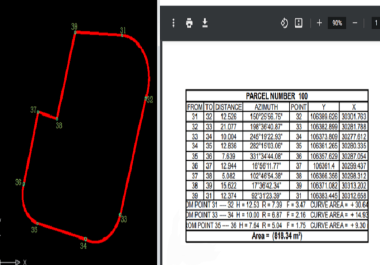
Based on the client’s AutoCAD DWG file – which must contain the land parcel drawn as a closed polyline on a dedicated layer with numbered points – I will prepare a professional land survey report in PDF format.The report includes a detailed table showing:· From → To (segment label)· Distance (length of each side)· Azimuth (direction of each side)· Point (point number)· X , Y (coordinates of each point)This report helps the buyer verify land area, dimensions, directions, and document official data for sale, purchase, or permit applications
Simple report (regular shape – 4 sides) 35USDMedium report (5–10 sides) 70 USDComplex report (irregular shape + area calculation + real coordinates) 100 USD
Simple report (regular shape – 4 sides) 35USDMedium report (5–10 sides) 70 USDComplex report (irregular shape + area calculation + real coordinates) 100 USD
Buy this service in two easy steps
Order Now $35